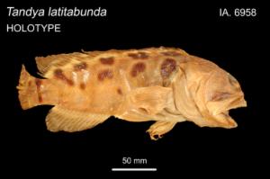
Occurrence record: Ichthyology:IA.6958
Preserved specimen
of
Opistognathus latitabundus
(Whitley, 1937)
| Blotched Jawfish
recorded on 1936
Images
Dataset
| Data partner | OZCAM (Online Zoological Collections of Australian Museums) Provider |
| Data resource | Australian Museum provider for OZCAM |
| Institution code |
Australian Museum
Supplied institution code "AM" |
| Collection |
Australian Museum Ichthyology Collection
Supplied collection code "Ichthyology" |
| Catalog number | IA.6958 |
| Other catalog numbers | ["ecatalogue.irn:8169862","urn:catalog:AM:Ichthyology:IA.6958"] |
| Occurrence ID | urn:lsid:ozcam.taxonomy.org.au:AM:Ichthyology:IA.6958 |
| Record type |
Preserved specimen
Supplied basis "PreservedSpecimen" |
| Preparations | ecatalogue.PreStorageMedium: "F"; |
| Identified by | Whitley, Mr Gilbert Percy - Australian Museum |
| Identified date | 1937 |
| Collector |
Allen, Mark
Supplied as "Mark Allen" |
| Specimen type | Holotype: Tandya latitabunda Whitley, 1937 : Opistognathidae : : : Chordata |
| License | CC-BY 3.0 (Au) |
| Presence/Absence | PRESENT |
| Date identified | 1937 |
| Identification remarks | ecatalogue.IdeConfidence: "N"; |
Event
| Event ID | urn:australianmuseum.net.au:Events:8018243 |
| Identification remarks | ecatalogue.IdeConfidence: "N"; |
| Occurrence date |
[date not supplied]
Year: 1936,
Month: ,
Day:
Supplied date "1936" |
| Date precision | YEAR |
Taxonomy
| Scientific name |
Opistognathus latitabundus
Supplied scientific name "Opistognathus latitabundus (Whitley, 1937)" |
| Identified to rank | species |
| Common name | Blotched Jawfish |
| Kingdom | Animalia |
| Phylum | Chordata |
| Class | Actinopterygii |
| Order | Perciformes |
| Family | Opistognathidae |
| Genus | Opistognathus |
| Species | Opistognathus latitabundus |
| Name match metric | exactMatch |
| Accepted name | Opistognathus latitabundus (Whitley, 1937) |
| Scientific name authorship | (Whitley, 1937) |
| Name parse type | SCIENTIFIC |
| Name according to | (Whitley, 1937) |
Geospatial
| Country | Australia |
| State or Territory | Queensland |
| Latitude |
-20.666 Supplied as: "-20.666" |
| Longitude |
148.75 Supplied as: "148.75" |
| Datum | EPSG:4326 |
| Verbatim locality | Port Newry, nr Mackay |
| Location remarks | ecatalogue.LocCollectionEventLocal: "[IA.6958] Australia, Queensland, Port Newry, nr Mackay (20° 40' S, 148° 45' E) 1936 - 1936, Volskou, C(Collector)"; |
| Coordinate precision | 0.001 |
| Terrestrial | true |
| Verbatim latitude | 20° 40' S |
| Biome | TERRESTRIAL |
| Marine | false |
| Country Code | AU |
| Verbatim longitude | 148° 45' E |
Additional properties
| dcterms:modified | 2018/6/27 |
| dcterms:type | PhysicalObject |
| dcterms modified | 2018/6/27 |
| dcterms type | PhysicalObject |
Data quality tests
| Test name | Result |
| Coordinate uncertainty meters invalid | Warning |
| Geodetic datum assumed WGS84 | Warning |
| Type status invalid | Warning |
| Show/Hide 92 passed properties | |
| Show/Hide 7 missing properties | |
| Show/Hide 22 tests that have not been run | |
Additional political boundaries information
| Area Management | |
| Australian Coral Ecoregions | Central & North GBR |
| CAPAD 2016 Marine | Great Barrier Reef |
| CAPAD 2020 Marine | Great Barrier Reef |
| Directory of Important Wetlands | Great Barrier Reef Marine Park |
| NRM Regions 2010 | Burdekin |
| NRM Regions 2017 | Burdekin |
| Area management | |
| National Landcare Program Management Units 2018 | Burdekin |
| Biodiversity | |
| IMCRA 4 Regions | Northeast Shelf Province |
| IMCRA Meso-scale Bioregions | Lucinda-Mackay Coast |
| Marine | |
| States including coastal waters | Queensland (including Coastal Waters) |
| Political | |
| Local Government Areas PSMA 2018 | TOWNSVILLE CITY |
| PSMA State Electoral Boundaries (2018) | MUNDINGBURRA |

